Things are well in Christina land. I really don't spend much time blogging, therefore no one follows my blog. If I had faithful readers perhaps I would be more faithful to write, but if I were faithful people would be interested in faithfully reading. Oh well.
Life is going along at a managable pace. I recently had the opportunity to come back south (to Alabama), with my friend, Rachel. Two and a half days, over 2000 miles, some good laughs, a smoky hotel room, closed interstate, and ice cream at Wall Drug.
So I quietly came to town and with the help of my sister, and brother-in-law, nicely surprised my parents. It's nice to be home without the stress of Christmas holidays. It's also nice to be here with leaves on the trees, and insects singing in the yard.
I'm enjoying my visit in stages. The first was spent in Huntsville, about five days with my sister and her husband (and a few days with his sister in town), This was followed by a few days in the Knoxville area with my brother, and my friend Rachel (from the road trip. You would think she would be tired of my by now, but maybe she's just going insane before she begins her through hike of the A.T. :) ) Anyway.
I'm now spending time at my parents' house.
I fly back on Monday. Back into work, Tuesday morning.
Friday, May 25, 2012
Thursday, March 24, 2011
Update
It's high time I update the un-identified void on the day and life of me (even though I don't know if anyone ever reads this thing. At this point in my life I hardly ever visit the blog myself).
This blog began as a class assignment in GeoVisualization.
Well, now, yours truly has graduated with my masters in geography. Last fall I actually taught the GeoVisualization course here at the local university.
These days I'm teaching Intro and Advanced GIS classes.
Jamie and I are getting on well. We are becoming Northwest skiers. Well, Jamie is truly trying; I should actually say he was trying. In January he stopped trying after a fall, a break and an ex-ray. So I'm still trying to ski and Jamie's simply trying to get to the point of walking normally again. We're both getting there.
This summer my sister and her husband are planning a trip out here. Yay.
The warmer months also hold camping plans for Jamie and I. We hope to buy some more equipment (oh how we collect sporting equipment. At least I'm not storing a boat . . . wait, actually I do have a kayak and paddle I left at my parents'. Maybe I should have fewer hobbies). Anyway, this summer we shall attempt to collect backpacks and a tent, and risk being eaten by bear or bugs in the backcountry world. We're both at least a little excited, although I'd rather avoid the bear part of the equation. Oh well. Maybe that's the price I pay for living in the west.
If you'de like the soon my most recent cartography work visit the University of Idaho's arboretum page and click on tour maps, and have a look at the Shattuck map.
Happy spring rays to all in the unknown void.
Tuesday, June 2, 2009
Today
Today has dawned nicely in Moscow, Idaho. A chill still hangs in the apartment air, even after 9 a.m. Living above the 45 degree graticule has helped to delay the summer heat.
Today I think I might get my hair cut. It's bothersomely long . . . for my tastes. It gets in the way. Besides that, it could use some shaping/styling.
I also have some university business to attend . . . sign a paper, get a class cleared and see about getting more funding for next semester. Speaking of school, I now have a non-thesis project that is reasonable enough to allow me to graduate next spring as planned. :) Sometimes I impress and/or suprise myself with what I accomplish . . . a masters of science . . . maybe I shouldn't toot my horn about a year in advance.
Thursday, May 7, 2009
Final Project
Introduction
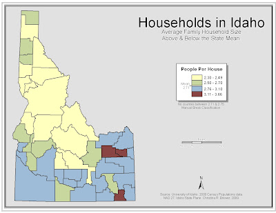
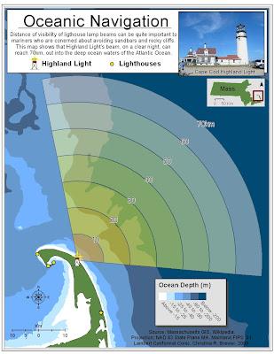
Maps show a variety of phenomenon within a spatial context. These to project maps shall show two very different, but interesting spatial features. Map 1 is a depiction of counties in Idaho with household sizes above and below the state’s mean household size. Map two is a multivariate map that shows the range of a lighthouse beam along with the varying ocean depths where the light may reach as well as surrounding waters.
Background
Map 1 displays average household size in each Idaho County and whether that county is above, or below the state average of 2.71 people per household. Values seem higher in the south and especially southeast portions of the state. This means that the average household is higher than the state average of 2.71 people per household.
This map is not meant for high end analysis. It can be used as a general, fast reference. This map was not designed for the purpose of textbooks, although it could be used for a human geography textbook, showing geographic phenomenon of social norms related with certain people groups. Map viewers should be able to see the trend over the state and understand where greater than or less than average values occur. My data was not adequate to establish an absolute conclusion.
Map two is a reference map showing the beam range of Highland Light on Cape Cod, Massachusetts mapped over nearby oceanic depths. Lighthouses are a navigational aid of mariners, as such, mariner are concerned about ocean depth and light visibility. This map shows that this lighthouse is easily visible in deep water, avoiding risk of sandbar grounding of vessels.
Map 1

Map 2

Wednesday, April 22, 2009
Map of the Week - National Public Lands Day
This weeks map is not a hard copy map so much as it is an interactive tool.
The National Public Lands Day web site contains a simple map of the U.S. Clicking on a state will do two things: tell you that state does not contain any sites, or direct the browser to a new page containing information about public lands day sites in that state. The info includes thing such as contact phone number, related website, directions, and a link to a locational map. Perhaps quite a useful tool for those interested in being involved with National Public Lands Day.
Please the following link to see this week's interactive map of the week.
http://www.publiclandsday.org/involved/sites.htm?
Exercise 7
Minority Racial Composition

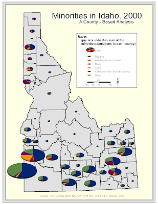
The following map is a pie chart map of Idaho showing some of the minority racial composition of each county. Pie slice shows the percentage of each race; whole pie size shows the sum of the minorities in each county. The data shows a larger quantity of these minorities in southern Idaho.
This map is somewhat limited in the placement of pie symbols. I would have liked to easily place them more nicely. Some smaller value pies' slices are not very discernable. Also, I would have liked to break the pies into a proportional, or graduaded symbol scheme in the legend.

Population Density & Elderly Populations
The following map shows elderly population in Idaho counties using graduated symbols. County population density is portrayed in darkening shades of blue (county background). The map shows a higher number of elderly in the south and northwest portions of the state. The map shows some counties with low population density, but higher numbers of elderly. This may be partially due to density being a function of county size.
The map is limited in the fact that it does not display elderly density, but rather raw quantities. This map give a deceptive picture of the percentage of elderly in each county.

Wednesday, April 15, 2009
Map of the Week - Wood?
This week's map is somewhat unconventional, but we see many ordinary maps . . . why not display some uncommon cartogaphic efforts.

Source: http://www.cbsled.com/relief_maps.html
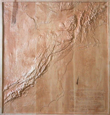
How about a map made of wood.
Check is out, a relief map carved in wood. This particular map shows the appalachian mountain range of the eastern U.S. It's kinda like the east's rocky mountains, but much shorter.
The map is suppose to depict the appalachian trail, which makes it's way from Georgia (in the south) to Maine (in the north), however, the trail could be better labeled (maybe a wood burning instrument), as well as state boundaries.
I would recommend viewing this map with a similar view from GoogleEarth. Some prominent land features: Cape Hatteras, and Cape Lookout (North Carolina), and Cape Cod (Mass.).

Source: http://www.cbsled.com/relief_maps.html
Subscribe to:
Comments (Atom)
